

Tropical Cyclone Zelia is expected to make landfall as a category three system on Thursday or Friday, but its path is being described as “erratic”.
Tropical Cyclone Zelia is expected to make landfall as a category three system on Thursday or Friday, but its path is being described as “erratic”.
By Heather McNeill
February 12, 2025 — 2.58pm
Tropical Cyclone Zelia is expected to make landfall as a category 3 system on Thursday or Friday, but its path is “erratic”, with communities between Karratha and Walla Downs in the Pilbara warned to expect a rain dump of up to 300 millimetres in one day.
Bureau of Meteorology WA spokesman James Ashley said the system, currently 180 kilometres off the Pilbara coast, was moving slowly in a southerly direction, and was expected to jut west.
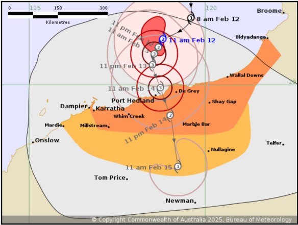
“The broader weather pattern is not conducive to confidence in the future motion of this system,” he said.
“It’s in an area where the steering flow for this system is quite weak so we’re expecting erratic motion and there’s low confidence on the future path of the system.”
Ashley said winds were predicted to reach up to 125km/h on Wednesday, and could increase to 200km/h as the cyclone made landfall.
Pilbara communities are also bracing for flooding, with many rivers already at capacity from previous rains.
“Regardless of intensity, we expect this system to produce very heavy rainfall, and areas close to the path could see in excess of 500 millimetres over the course of this event,” Ashley said.
“This very heavy rainfall is likely to produce significant flooding.”
Department of Fire and Emergency Services Commissioner Darren Klemm said emergency services were preparing for some areas to receive between 200 and 300 millimetres over a 24-hour period.
Advertisement
“DFES has significantly boosted its resources in the Pilbara and the Kimberley with additional personal into our incident management teams in both Broome and Karratha as well as operational on-the-ground personnel, rapid damage assessment teams into Nullagine and Marble Bar and in the Pilbara more generally,” he said.
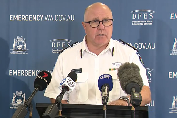
Klemm said DFES was also bringing in flood boats, planes and a rescue helicopter.
An evacuation centre will be opened in Port Hedland once the cyclone alert reaches a watch and act.
Road access to the North West, including the North West Highway, is expected to be impacted for up to a week due to extensive flooding.
“I think people should expect that some of these major highways are going to be closed and potentially for up to a week or potentially even longer depending on any damage,” Klemm said.
Remote communities are being stocked in preparation for being temporarily cut off from supply chains.
Get to the heart of what’s happening with climate change and the environment. Sign up for our fortnightly Environment newsletter.
Heather McNeill is the deputy editor and chief reporter at WAtoday.Connect via Twitter.
Loading
Discover more from World Byte News
Subscribe to get the latest posts sent to your email.