
The West Australian mining towns of Karratha and Port Hedland are both at risk of a “direct impact” from Severe Tropical Cyclone Zelia, which is expected to make landfall on Friday afternoon.
The West Australian mining towns of Karratha and Port Hedland are both at risk of a “direct impact” from Severe Tropical Cyclone Zelia, which is expected to make landfall on Friday afternoon.
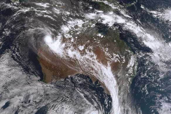
Welcome to our live blog as Western Australia’s north prepares for a category 5 cyclone to cross the coast on Friday afternoon.
The West Australian mining towns of Karratha and Port Hedland are both at risk of a “direct impact” from Severe Tropical Cyclone Zelia.
The Bureau of Meteorology said the category five system’s path remained unpredictable and problematic, with thousands of residents along the Pilbara coast bracing for its impact.
It’s expected to generate wind gusts up to 290km/h, and dump more than 500 millimetres of rain in the worst affected areas. High tides and already overflowing river catchments could also compound major flooding in coastal areas prompting roads into the region to be closed.
“It doesn’t get any worse than that, that is the most powerful tropical cyclone you can get,” senior meteorologist Angus Hines said.
“It’s an organised and powerful tropical cyclone that will play a significant role in the weather across this part of the country over the next few days.”
Stay with us as we bring you cyclone news as it breaks.
We’re wrapping up our live blog for the day, thank you for joining us.
We’ll be back first thing in the morning with more in depth coverage of cyclone Zelia as it tracks closer to the coast. It’s expected to make landfall at around 8pm on Friday.
Here are some of the headlines we covered today:
Thank you again for tuning in. We’ll see you tomorrow for more news you need to know.
The eye of the storm for Cyclone Zelia has all but disappeared from the radar as the intense system undergoes an eye wall replacement cycle late on Thursday afternoon.
Miriam Bradbury from the Bureau of Meteorology said the phenomenon only happens with severe cyclones.
Credit: BoM
“That strong core of the system, the tropical cyclone eye, is less well-defined than it was earlier today,” she said.
“That is because severe Tropical Cyclone Zelia is currently undergoing an eye wall replacement cycle, something that only happens in our most intensive cyclones.”
Bradbury said the cyclone was moving slowly over warm ocean waters on Thursday evening, which would help it maintain its category five intensity through to the time of crossing.
“Tomorrow night, we’re seeing feeder bands of showers and storms pulling into this system and spraying out across parts of the Kimberley and Pilbara, delivering locally heavy falls to some of those areas,” she said.
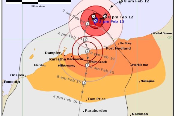
“Our latest tropical cyclone forecast track map, we can see that Zelia is expected to make a southerly turn in its track overnight into tomorrow morning.
“It will move gradually towards the Pilbara coast through tomorrow, most likely to make a coastal crossing somewhere between Port Headland and Roebourne tomorrow night.”
Destructive wind gusts up to 320 kilometres an hour are expected when the core of that system moves across the coast.
A truck driver is lucky to be alive after he was rescued after his road train was caught in floodwaters near Marble Bar on Thursday morning.
The driver was spotted by a Main Roads site camera standing on his partially submerged truck on Ripon Hills Road just after 10am.
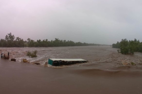
A helicopter crew was dispatched from Newman, with the driver rescued just after 1pm.
A DFES spokesman said the driver was taken to the nearby Woody Woody mine site to be assessed by paramedics. It is unknown what condition the driver is in.
Main Roads broadcast the closure on the Ripon Hills Road between Marble Bar Road to the Telfer mine turn off just after 7am on Thursday morning.
The Department of Communities opened up an evacuation centre at Karratha Leisureplex at 3pm.
Former Karratha resident Cindy Newhouse said people she had spoken to in the town had never seen anything like the monster cyclone brewing off the coast.
She said many residents were helping friends and family prepare ahead of its 8pm landfall on Friday evening and others were leaving town, especially those with young children.
“People are worried it will smash the town and that the Whim Creek pub won’t survive the cyclone,” she said.
“Residents are scared because they know the slower the cyclone moves towards the coast the more it intensifies.“
Newhouse experienced Cyclone Damian in 2020 and said it was impossible to drive down the street in the aftermath.
“As the cyclone comes closer to the coast it’s growing and then all of a sudden everything stops when the eye passes over and its dead calm,” she said.
“You’d think it was over if you didn’t know better but then the other side comes and its instantly intense.”
The Bureau of Meteorology has released a new video discussing Zelia and what is to come over the next 24 to 48 hours.
The prediction now is wind gusts of up to 320km/h when the core of the cyclone crosses the coast Friday night.
“Winds that strong will destroy anything in their path,” senior meteorologist Miriam Bradbury said.
“Trees, cars and permanent structures will all be wiped away. Heavy rainfall is also likely to increase as the system nears the coast.”
The following alert has been issued by the Department of Fire and Emergency Services.
Flooding is likely in parts of the Pilbara. See flood warnings on Emergency WA for the latest information.
No matter how many cyclones you have been through, a severe cyclone can be overwhelming. If you plan to shelter at home, make sure you and your family are physically and mentally prepared. If you are unsure, an evacuation centre may be the safer choice.
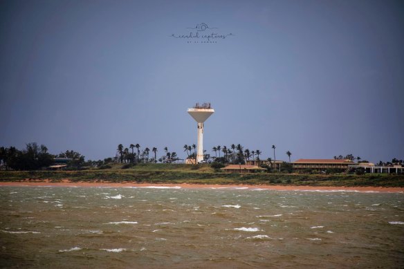
The Cyclone Watch and Act is in place for Eighty Mile Beach to Dampier, including Karratha and inland to Marble Bar and Millstream.
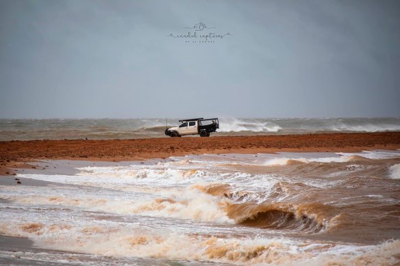
There is a possible threat to lives and homes as a cyclone is approaching the area.
You need to take action and get ready to shelter from a cyclone.
WHAT TO DO
Premier Roger Cook has issued a warning to Pilbara residents to be prepared for Cyclone Zelia ahead of its landfall tomorrow.
“This is a dangerous system. It’s big, it’s strong, and it’s very unpredictable,” he said.
“Now we know people of the Pilbara are used to cyclones coming through. They’re ready. They’re match fit, but please be prepared.

“This is going to be a big one, and we need everyone to do the right thing, making sure that you’ve done everything to keep your home safe. Make sure you get to an evacuation centre if that’s necessary but, in particular, listen to the emergency authorities, make sure you do the right thing.”
The Bureau has just released an updated cyclone tracking map which shows Whim Creek could now be in line to take a direct hit from the category 5 system.
The area has few buildings or residents, with the historic Whim Creek Hotel the main attraction for commuters making the two-hour drive between the mining towns of Karratha and Port Hedland.
As the category 5 system bears down on the mining town of Port Hedland, the Bureau of Meteorology and the Department of Fire and Emergency Services have expressed concerns about whether older buildings in the area can withstand 290km/h winds.
BOM spokesman Angus Hines said a category 5 is “strong enough to take out complete houses, trees and power lines and cause widespread damage and destruction”.

DFES Commissioner Darren Klemm said he was particularly concerned about buildings in Port Hedland, with the path of the storm still unclear.
“I think the housing stock in Port Hedland is a bit older than what it is in Karratha and so that’s where some of those maintenance issues come in … have they been maintained to appropriate standard?,” he said.
“I urge people in Port Hedland, obviously keep an eye on the [cyclone] track, the evacuation centre is there if you’re not comfortable with where you are.”
James Cook University associate professor Geoff Boughton said that most houses in Port Hedland were built to withstand a severe cyclone, but some may not have been maintained over the years and could be vulnerable.
“If a piece of debris smashes a window … that allows the wind into the building and that can push up on the underside of the roof and doubles the load on the building,” he told ABC Radio.
He said that some houses in the town did fail in 2007 when Tropical Cyclone George passed through with wind speeds akin to a category 3 system.
Discover more from World Byte News
Subscribe to get the latest posts sent to your email.