

There is no shortage of obstacles facing a rain-hit region as it tries to recover from a deadly deluge.
There is no shortage of obstacles facing a rain-hit region as it tries to recover from a deadly deluge.
By Fraser Barton and Savannah Meacham
February 10, 2025 — 7.24pm
Landslides, fallen trees and flooding. Lots of flooding.
There is no shortage of obstacles facing a rain-hit region as it tries to recover from a deadly deluge.
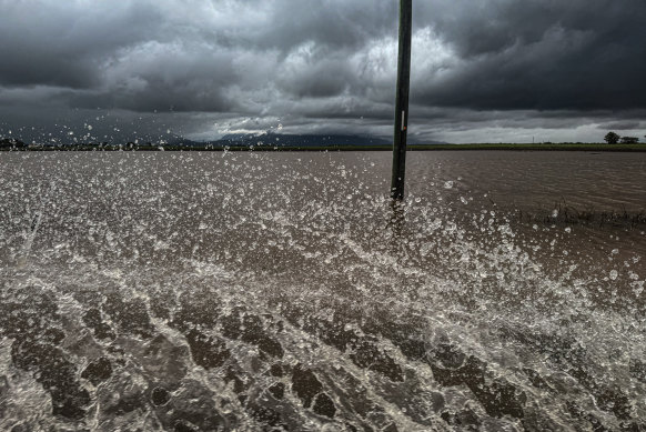
Yet more communities look set to be impacted after Queensland’s big wet spread west, leaving motorists stranded alongside highways.
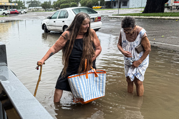
Record rainfall has cut off roads, forced hundreds to evacuate and claimed two lives in north Queensland since the heavens opened more than a week ago.
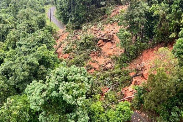
More than 30,000 people at one stage lost power, with a massive landslide near Townsville hampering efforts to restore access to the energy grid.
Heavy rainfall is set to continue along the north Queensland coast, prompting a state MP to remain in his flood-hit electorate rather than attend a parliamentary hearing on the Gold Coast.
Army helicopters have been used to check on the isolated Charters Towers community near Townsville, with locals warned to restrict their water use.
A severe weather warning from Innisfail down the coast to Ayr has been expanded inland to Gulf Country.
Advertisement
At least six communities have been isolated by floodwaters after northwest areas between Georgetown and Normanton received more than 300 millimetres of rainfall overnight, with more to come.
Some areas are relying on supply drops from helicopters and planes as they brace for what may be a long wait for inundated roads to clear.
“Given the amount of water in those systems, it could be three-to-four days [of isolation], it could be eight-to-10 days,” Etheridge Shire Mayor Barry Hughes said.
Heavy rain and flash flooding is expected to hit Queensland’s Gulf Country with falls up to 250mm over the next day.
“We have had instances where we’ve had travellers stranded on the side of the road on some of the western highways,” Transport Minister Brent Mickelberg said.
“Many of those roads are closed and will be closed for extended periods of time.”
Rainfall is finally set to ease on Wednesday, with crews focusing on clearing Queensland’s main arterial link, the Bruce Highway, to ensure supplies for rain-hit communities.
Some coastal regions have already set February rainfall records just 10 days into the month after recording more than 1500 millimetres.
Ingham was one of the worst-affected areas, with the army stepping in to help rebuild a bridge crossing after it was completely isolated by floodwaters.
Floodwaters claimed the lives of two women in the region after the nearby Herbert River, in the Hinchinbrook Shire, broke a record level set in 1967.
Local state MP Nick Dametto said he would remain in the region to help the recovery instead of attending a parliamentary hearing on elder abuse.
“The flooding and isolation being felt in the Hinchinbrook Shire is something I’ve never seen before,” he said.
“Most of us are just running on fumes … it’s important for me to be here right now.”
Power is close to being restored to every Ingham household, more than a week after the substation was inundated.
About 1600 residents remain without power across the north and requests for help continue to be made in flood-affected regions.
Severe thunderstorms have continued to ravage the country’s southeast with hail up to six centimetres in central and eastern NSW and flash flooding in eastern Victoria.
Western Australia’s Kimberley region is bracing for a possible tropical cyclone that could form by Tuesday.
The warning zone stretches across 350 kilometres between Cockatoo Island and Bidyadanga, including Broome.
Loading
Discover more from World Byte News
Subscribe to get the latest posts sent to your email.