


Tropical Cyclone Alfred’s forecast arrival has been pushed back by 24 hours after the category 2 storm stalled off Australia’s east coast. Follow our live coverage.
Tropical Cyclone Alfred’s forecast arrival has been pushed back by 24 hours after the category 2 storm stalled off Australia’s east coast. Follow our live coverage.
Hello and welcome to our live coverage as Cyclone Alfred approaches the Queensland coast,triggering evacuation orders in northern NSW.
Here is a recap of key developments:
- Alfred is set to cross Queensland’s coast near Caboolture north of Brisbane around 8am on Saturday (AEDT), 24 hours later than initially predicted.
- The latest track map released by the Bureau of Meteorology shows the tropical cyclone’s anticipated landing time at 7am Saturday, Queensland time.
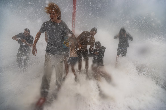
- The cyclone is expected to lash northern NSW and southeast Queensland with heavy rain and wind, forecast to peak late on Friday and early Saturday.
- The cyclone is set to trigger wind gusts up to 155km/h and 800mm of rain into the weekend from Brisbane to NSW’s Northern Rivers when it eventually arrives.
- Residents in certain parts of North Macksville, Macksville, Bowraville, Nambucca Heads and Gumma have been told to evacuate by 8am, Friday March 7 due to anticipated flooding.
- Schools, public transport, major roads and airports are closed, with elective surgeries also put on hold, but emergency departments remain open.
- Supermarkets have started to shut down across northern NSW and Queensland’s southeast as they brace for Alfred.
- The tropical cyclone will be the first to hit southeast Queensland and northeast NSW in more than 50 years.
Tropical Cyclone Alfred’s forecast arrival has been pushed back by 24 hours after the category 2 storm stalled off Australia’s east coast.
The track map released on Thursday night by the Bureau of Meteorology shows the cyclone’s landing time further delayed until 7am Saturday, Queensland time. Cyclone Alfred has dropped in speed to 6 kilometres per hour, and has remained the same distance from land since 5pm.
The cyclone was expected to cross the coast early on Saturday morning between Noosa and Coolangatta.
Forecasts suggest the cyclone could be downgraded in severity to a category 1 storm, but meteorologists warn the delayed landfall could prolong severe weather conditions and remain a major threat to communities.


The NSW SES released a second round of evacuation notices for more areas in northern NSW, after telling residents in Lismore earlier to evacuate by Thursday night.
Residents in certain parts of North Macksville, Macksville, Bowraville, Nambucca Heads and Gumma have been told to evacuate by 8am Friday, March 7.

“You must evacuate before this time because forecasted heavy rainfall will close evacuation routes,” the SES said.
“If you remain in the area, you may become trapped without power, water, and other essential services. It may be too dangerous for NSW SES to rescue you, and buildings may not be able to withstand the impact of flood water.”
Specific roads and streets have been told to evacuate, and can be found here.
Hello and welcome to our live coverage as Cyclone Alfred approaches the Queensland coast,triggering evacuation orders in northern NSW.
Here is a recap of key developments:
- Alfred is set to cross Queensland’s coast near Caboolture north of Brisbane around 8am on Saturday (AEDT), 24 hours later than initially predicted.
- The latest track map released by the Bureau of Meteorology shows the tropical cyclone’s anticipated landing time at 7am Saturday, Queensland time.
- The cyclone is expected to lash northern NSW and southeast Queensland with heavy rain and wind, forecast to peak late on Friday and early Saturday.
- The cyclone is set to trigger wind gusts up to 155km/h and 800mm of rain into the weekend from Brisbane to NSW’s Northern Rivers when it eventually arrives.
- Residents in certain parts of North Macksville, Macksville, Bowraville, Nambucca Heads and Gumma have been told to evacuate by 8am, Friday March 7 due to anticipated flooding.
- Schools, public transport, major roads and airports are closed, with elective surgeries also put on hold, but emergency departments remain open.
- Supermarkets have started to shut down across northern NSW and Queensland’s southeast as they brace for Alfred.
- The tropical cyclone will be the first to hit southeast Queensland and northeast NSW in more than 50 years.