


Residents in Port Hedland and surrounding areas have been ordered to stay indoors and shelter as winds pick up, with the centre expected to cross the coast this afternoon.
Residents in Port Hedland and surrounding areas have been ordered to stay indoors and shelter as winds pick up, with the centre expected to cross the coast this afternoon.
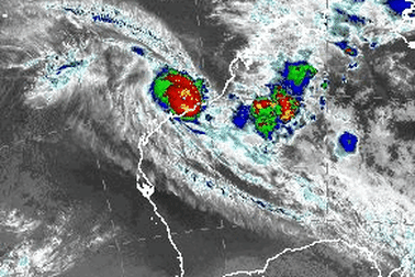
Back to the Bureau of Meteorology, which has just released updated advice.
Winds near the centre of TC Zelia are now more than 200km/h, with gusts recorded up to 285km/h.
She is still moving slowly, at just 8km/h southeast towards the coast.
The cyclone is expected to hit near, or to the east, of Port Hedland and will then take a general southerly track overland and gradually weaken.
Intense rainfall is expected near and to the east of the centre of the cyclone as it crosses the coast.
While there is still a storm tide warning in place, the latest observations decrease the risk of the storm tide for noon today at Port Hedland.
Tides are still likely to rise significantly above the normal high tide mark with damaging waves and dangerous flooding of some low-lying areas close to the shoreline.
Streets are flooded as rain continues to fall in the emergency zone, with residents sharing videos and photos from the scene.
Pardoo, which is up the coast from Port Hedland, has recorded 228mm of rain in the past 24 hours.
Wind gusts in Port Hedland are reaching about 80km/h.
Experts from across Australia are watching closely as Severe Tropical Cyclone Zelia approaches the Pilbara coast.
Professor Steve Turton – an adjunct professor of environmental geography at the Central Queensland University – said he was “particularly worried” about Port Hedland.
“Even buildings and infrastructure built to the highest cyclone rating standards will receive some structural damage from the predicted extreme winds in the core of the cyclone,” he said.

“It’s at the top of the category 5 scale.
“The record-breaking sea surface temperatures offshore (over 31 degrees) are feeding this monster, along with exceptionally favourable atmospheric conditions.”
Turton said the system’s slow forward motion would make for prolonged extreme winds and intense rainfall around the core as it crossed the coast.
“It’s too early to draw a direct link between global heating and this particular cyclone, but its rapid rate of intensification and the exceptionally warm ocean heat content suggest aspects of this extreme weather event may be attributed to anthropogenic climate change,” he said.
“Great Hurricane Milton in the Gulf of Mexico last October is the most recent global example of such an intense system. Luckily it weakened considerably before hitting central western Florida.”
Nine News Perth reporter Sarah Smith is in Port Hedland, reporting as the Category 5 storm approaches.
“Everyone in Port Hedland is in lockdown, there is nobody on the streets,” she said from the safety of the Hedland Hotel.
“It’s very windy, very rainy and it’s a nervous wait for locals with the cyclone due to hit a lot earlier than had been predicted.”
TC Zelia is now expected this afternoon, rather than evening.
Smith said people had flocked to the shops in town to stock up on water and food yesterday as they prepared as much as they could.
Many had been hard at work sandbagging homes and businesses.
“It’s a ghost town, and now everybody is indoors bracing for what’s to come,” she said.
“It’s completely grey skies and palm trees blowing in the wind.”
The Bureau of Meteorology’s Angus Hines was on Nine’s Today show earlier this morning, where he gave a more accurate forecast of Severe Tropical Cyclone Zelia’s coastal crossing.
Hines said the earlier crossing – predicted between 2pm and 4pm on Friday to the east of Port Hedland – was one of the “significant shifts” in the forecast from Thursday night.
Here’s what the meteorologist had to say:
We are expecting Severe Tropical Cyclone Zelia, this category 5 system – which is as strong as they get, it does not get stronger than category 5 – to make landfall, to make a coastal crossing in the next few hours, and there have been a couple of significant shifts since what we saw yesterday evening.
Firstly, it has been brought a little bit earlier; we were thinking about an evening crossing when we were talking about it yesterday, but today that’s been brought forward to the afternoon.
So perhaps between 2pm and 4pm this afternoon is now the most up-to-date forecast for the crossing time of the tropical cyclone.
Also, the area has shifted slightly as well, we are now looking at east of Port Hedland as being the likely location of this coastal crossing, perhaps anywhere from about 20 to 50 kilometres east of Port Hedland.
Areas including Port Hedland in and around that region could bear the brunt of that impact.
We’ve already seen heavy rainfall and flooding occurring across the Pilbara coast over the last couple of days, even as this tropical cyclone is gathering strength, and that rainfall is only going to continue
Then wind is going to be a major issue – we’re talking about winds nearly 300km/h as a possibility.
It’s pretty hard to fathom wind that strong if you’ve never experienced it before, that is incredibly powerful wind, that is absolutely enough to rip out trees, take down power lines and knock down structures, including property and houses as well.
The very, very strongest winds will be closest to where the crossing occurs, which is why that crossing is so important because that is where the extremely destructive winds will occur.
Winds are already strong in the area near Port Hedland, with gusts to 120 km/h occurring near the coastal fringe between Pardoo and Whim Creek.
Gales with gusts to 90 km/h may extend to other areas along the coast between Wallal Downs and Dampier, including the town of Karratha where about 17,000 people live if the track deviates from what is forecast.

The remote area is not unaccustomed to cyclones.
The Pardoo Roadhouse, which is again in the line of fire, was decimated by Cyclone Ilsa in 2023.
Cyclone Ilsa was the most severe cyclone to make landfall in Australian history at the time, and it tracked directly over Pardoo Roadhouse as a category 5 system.
The property was one of few to feel the full impact of the cyclone, which moved across scarcely populated land, missing the towns in the region.

Zelia is moving south-east at the slow speed of 7km/h, which is allowing it to gather intensity as it nears the coast of Port Hedland, the epicentre of Australia’s iron ore industry.
Around 16,000 people live in the town in Western Australia’s North West.
It’s the home of Australia’s largest bulk export port. The port itself has been shut down, with big industry putting in place plans to keep staff safe.
The system’s path has been described by authorities as erratic and unpredictable.
The Bureau of Meteorology previously forecast the cyclone would pass over the Pilbara somewhere between Karratha and De Grey, but a new forecast on Friday morning put the crossing almost directly on top of Port Hedland.
Throughout Thursday, the bureau’s predicted path showed the system moving west, potentially passing closer to Whim Creek, before it swung back east overnight.
The dangerous system rapidly intensified into a category 5 storm on Thursday after the “perfect ingredients” of warm sea temperatures, moisture, low-level winds and a slow-moving system combined overnight.
Residents in the Port Hedland area have been ordered to stay indoors and in the safest part of their home.
The Bureau of Meteorology is not holding back on warning locals about the severity of what they’re facing.

Wind gusts of up to 290km/h are possible when the core of the cyclone crosses the coast.
“Winds that strong will destroy anything in their path,” senior meteorologist Miriam Bradbury said.
“Trees, cars and permanent structures will all be wiped away. Heavy rainfall is also likely to increase as the system nears the coast.”
Tropical cyclones of any size can be dangerous, producing extreme winds, heavy rainfall with flooding and damaging storm surges which can inundate coastal areas, the Bureau of Meteorology says. This may be the most dangerous hazard resulting from a cyclone.
The most powerful winds are near the centre, and can turn airborne debris into missiles.
Luckily, Pilbara buildings are designed to withstand strong winds due to the region’s regular encounter with cyclones, but Zelia may put them to the test.
Good morning and welcome to our Severe Tropical Cyclone Zelia live blog.
We wake to the news that Zelia is headed directly for the town of Port Hedland and is now expected to cross the coast between 2pm to 4pm today as a category 5 cyclone, the strongest intensity on the tropical cyclone scale.
The cyclone has started moving south, with winds near its centre at 205km/h and gusts to 285km/h.

It’s looking like a worst-case scenario for Port Hedland, with new mapping showing the cyclone is now predicted to cross the coast at the same time as high tide, around 1pm WA time.
Bureau of Meteorology hazard preparedness and response WA manager James Ashley explained yesterday: “The state of the tide really is crucial to the impact of the storm surge component of the cyclone.
“If that cyclone crossing occurs at the time of high tide, the storm surge is significantly worse.
“Tidal ranges up through the Pilbara are quite large. So, a crossing at low tide is unlikely to even reach the highest astronomical tide of the year, but a crossing at the time of high tide could significantly be above that level.”
The tidal range and the time of the coastal crossing is going to be critical to the impacts of that storm surge.
Late last night, authorities issued an emergency warning for Port Hedland and surrounding areas, instructing residents to shelter indoors immediately.
The warning area stretches inland to west of Marble Bar, as Severe Tropical Cyclone Zelia slowly moves towards the Pilbara coast of Western Australia.