


The ADF has been briefed, Brisbane police have been deployed, 300 energy staff are on standby, and crocs have been sighted in floodwaters, as the risk of flash flooding rises.
The ADF has been briefed, Brisbane police have been deployed, 300 energy staff are on standby, and crocs have been sighted in floodwaters, as the risk of flash flooding rises.
By Fraser Barton and Alex Mitchell
February 1, 2025 — 10.52am
There’s no end in sight to the biblical rain that has pounded Queensland’s northern tip, with major flooding predicted.
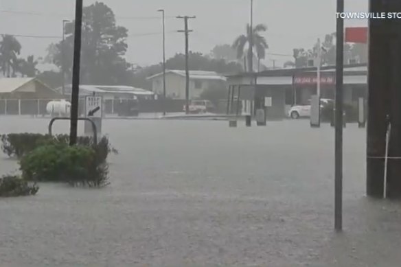
Overnight deluges have brought widespread falls of 150mm to 250mm since 9am on Friday, with some parts of Townsville receiving a whopping 350mm in just 24 hours.
The torrential rain has caused road closures and multiple rescues, with tropical lows looming off the coast.
Almost 40 police officers have been sent north from Brisbane, with rescue boats positioned from Townsville to Cairns.
About 300 energy staff are also on standby, and the Australian Defence Force has been briefed as authorities brace for more wet weather.
The low-pressure system off Cairns is unlikely to develop into a cyclone but has brought a deluge to the north tropical coast, with seven-day rainfall totals of up to 700mm in some areas.

The Bureau of Meteorology has warned that a 550-kilometre stretch of the east coast, between Bowen and Cairns, can expect the rain to continue in the coming days.
“Not only [Saturday], but also [Sunday] could see thunderstorms as well in those areas that could bring isolated, very heavy falls of up to 50mm to 100mm in an hour,” senior meteorologist Dean Narramore said.
Advertisement
“That could produce dangerous and life-threatening flash-flooding.”
Various flood warnings are in place across the area, as a diminished cyclone threat brings plenty of rain with it.
Another low in the Gulf of Carpentaria was set to weaken, but a system in the Coral Sea near Vanuatu could develop into a cyclone from Sunday.
Areas such as Townsville are already drenched, with a string of social media posts reporting crocodiles in floodwaters.

Multiple swiftwater rescue firefighters sprang into action when a person was reported missing in floodwaters in Townsville’s Hyde Park on Friday, but they were found safe 40 minutes later having “self-extricated from the water”, said Queensland Fire and Rescue.
The Bruce Highway – Queensland’s major arterial road – was closed on Friday north of Bowen after severe flash flooding.
“We’ve had a hell of a lot of rain the last 24 hours. It seems to be sort of in different areas at different times,” Whitsunday Regional Council Mayor Ry Collins said.
“It’s not an unexpected issue, but one that still causes some headaches for anyone on the highway.”
Emergency service reinforcements have been sent north in preparation for the next deluge.
“We may, in fact, see intense rainfall across parts of this coastline over the next few days, particularly between Innisfail and Ayr,” the weather bureau’s Miriam Bradbury said.

“It could lead to life-threatening flash flooding. Now, that’s more than just water moving over roads and footpaths possibly coming into your home.”
On Friday evening, an emergency flood alert was issued for Townsville by the local disaster management group, saying people should be prepared to leave as conditions could change quickly.
Minor flood warnings were in place for the Mulgrave, Tully, Murray and Don rivers, with flood watches extending across the north tropical coast.
Loading