

The storm left Sydney’s public transport on its knees and roads inundated as more than 85 millimetres of rain fell in some parts of the city.
The storm left Sydney’s public transport on its knees and roads inundated as more than 85 millimetres of rain fell in some parts of the city.
By Jessica McSweeney and Riley Walter
Updated February 10, 2025 — 4.13pmfirst published at 10.52am
More than 20 people have been rescued from floodwaters after a severe thunderstorm drenched Sydney with almost 100 millimetres of rain and caused traffic chaos.
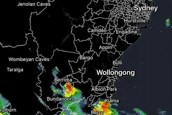
The large weather system passed over the Blue Mountains and western Sydney by late morning and hit the city about midday, with the massive downpours and life-threatening flash-flooding inundating roads and disrupting public transport.
The storm dumped 88.2 millimetres on Horsley Park in western Sydney. More than 53 millimetres drenched Observatory Hill in the city, while 46.2 millimetres were recorded in Penrith.
Roads across Sydney were flooded with knee-high water, including Bridge Road near the Fish Market, at Riverstone in the city’s north-west and Rushcutters Bay in the east.
NSW SES commander Stuart Fisher said 21 people had been rescued from floodwaters across Sydney after becoming trapped in their cars.
He said motorists ignoring repeated warnings to avoid driving in floodwaters was “frustrating”.
“The drivers don’t hear our message, which is do not drive through flooded waters,” Fisher said.
“It doesn’t take a lot to get a car stuck these days, and the cars are very lightweight so it has the potential to move them off the road and into danger.
Advertisement
“It’s not worth putting your life at risk.”
The SES received more than 300 callouts after the storm. More than 550 incidents were reported across NSW overnight Sunday and into Monday.
The storm also left Sydney’s public transport on its knees. Light rail services on the L2 Randwick and L3 Kingsford Line were closed due to flooding. Flooding at Strathfield railway station also led to delays across multiple train lines.
Further thunderstorms could hit Sydney into the late afternoon and evening, and the Bureau of Meteorology is predicting the chance of less severe thunderstorms on Tuesday before conditions ease on Wednesday.
The bureau warned that Gosford, Sydney, Orange, Katoomba, Dubbo and Parkes were of particular concern.
“I think everyone will be copping a bit of weather today,” the bureau’s Helen Reid said.
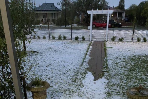
Early on Monday morning, the storm dumped an extraordinary amount of hail onto Harden, a small town near Cootamundra, leaving it blanketed with a layer of ice. Shops and homes were flooded, windows were smashed and wildlife found injured.
An animal ambulance was deployed from Sydney to treat multiple wild birds left seriously injured from the hail. The SES responded to more than 120 callouts in the town.
The thunderstorms are forming on a surface trough in a moist, unstable air mass in inland NSW, with an upper trough moving them across the state towards the coast.
Start the day with a summary of the day’s most important and interesting stories, analysis and insights. Sign up for our Morning Edition newsletter.
Jessica McSweeney is a breaking news reporter at The Sydney Morning Herald.Connect via email.
Riley Walter is a breaking news reporter at The Sydney Morning Herald.Connect via Twitter or email.
Loading
Discover more from World Byte News
Subscribe to get the latest posts sent to your email.