

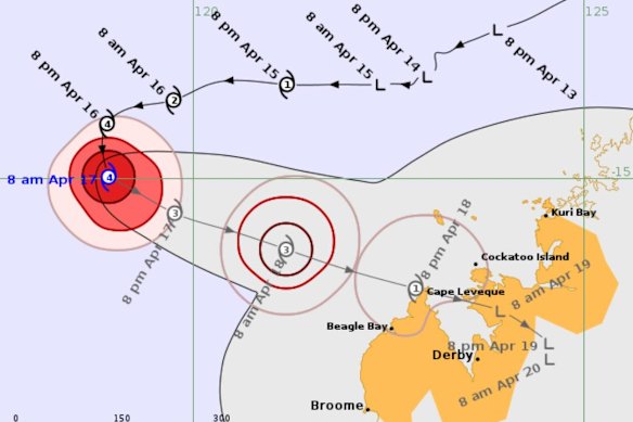
Errol had been heading west away from Australia before it made a sharp U-turn and is now moving towards the northwest coast.
Errol had been heading west away from Australia before it made a sharp U-turn and is now moving towards the northwest coast.
By Savannah Meacham
April 17, 2025 — 10.55am
A cyclone has strengthened to a category four system after making a sharp U-turn towards regional communities already battered by an earlier weather event.
Tropical Cyclone Errol is offshore about 500 kilometres northwest of Broome and is beginning to track towards the West Australian coast, expected to bear down on the Easter weekend.
The system intensified overnight to a category four system – the second-highest classification that could cause structural damage from severe winds, power loss and a high storm surge.
Errol had been heading west away from Australia before it made a sharp U-turn and is now moving towards the northwest coast.
Forecasters expect Errol to move slowly southeast, maintaining a category four strength on Thursday.
It will take days for Errol to reach the coast and no significant wind or rain is forecast on Thursday but communities may start to feel the effects in the coming days.
Conditions will ramp up for the Kimberley on Good Friday, while the system will begin weakening and is expected to drop to a category one by the time it nears the coast.
“It’s still expected to bring strong to damaging winds, heavy rain, thunderstorms from Friday afternoon through until Saturday,” meteorologist Angus Hines said.
Errol will likely arrive somewhere around the northern tip of the Dampier Peninsula on Saturday morning as a category-one system.
A category-one system can produce maximum wind speeds of 88km/h with gusts of 125km/h, which will likely cause little house damage but some destruction to crops and trees.
A cyclone watch has been issued for the Kimberley coast stretching from Broome to Kuri Bay, including Cape Leveque and Derby.
The watch warns the remote communities of gale force winds along the stretch of coastline in the next 48 hours.
Northern WA has already had one cyclone this season as ex-tropical cyclone Sean reached a category three but steered away from the coastline.
It brought wind gusts of 104km/h and heavy rainfall, with Karratha copping 274mm in 24 hours, exceeding its highest annual rain record.
Flooding was reported in some communities and trees fell on properties and cars during the storm.
AAP
Discover more from World Byte News
Subscribe to get the latest posts sent to your email.