





Cyclone Alfred is expected to make landfall late Thursday, or early Friday morning. What damage will it cause, and where will it flood? We answer your questions.
Cyclone Alfred is expected to make landfall late Thursday, or early Friday morning. What damage will it cause, and where will it flood? We answer your questions.
- Updated
- National
- Queensland
- Extreme weather
By Marissa Calligeros
Updated March 5, 2025 — 10.19amfirst published March 4, 2025 — 5.00am
More than 4 million people are now in the firing line of Cyclone Alfred as it tracks towards Brisbane.
About 20,000 homes in Brisbane, and more across south-east Queensland and northern NSW, are at risk of flooding from torrential rain and storm surges.
When is Cyclone Alfred expected to hit?
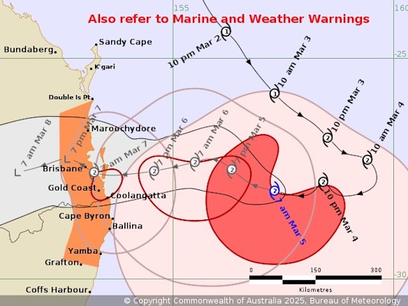
Alfred is expected to make landfall over Brisbane, just south of the CBD, as a high-end category 2 cyclone in the early hours of Friday morning.
“The possibility of the system reaching a low-end category 3 strength before making landfall cannot be ruled out, but remains a low risk,” the Bureau of Meteorology said on Wednesday morning.
In its updated forecast, the Bureau said Alfred was due to strike further south than previously predicted, with Brisbane directly in the firing line.
Its effects are already being felt in Brisbane and along the Sunshine and Gold coasts, with huge swells and high tides causing beach erosion, and strong winds.
The heavy rain and damaging winds could start hitting south-east Queensland from Wednesday afternoon, ahead of Alfred’s official coastal crossing.
What is its predicted path?
Advertisement
Alfred was 425 kilometres east of Brisbane, moving towards the coast at a speed of 11km/h, on Wednesday morning. It is expected to maintain its intensity as it tracks towards the Queensland capital as a category 2 storm.
As of Wednesday morning, it was expected to make landfall over Brisbane, but its effects could be felt all the way south to northern NSW, from Byron Bay to Lismore and Yamba, and possibly Grafton.
Where is it expected to flood?
More than 20,000 properties in Brisbane could experience anything from mild inundation in their backyards to significant flooding in their homes.
The Brisbane suburbs at most risk include Brighton, Windsor, Ashgrove, Morningside, Rocklea, Coopers Plains, Carina, Sandgate, Hemmant, Lota, Tingalpa, Indooroopilly, Albion, Bardon and Wynnum West.
A flood watch is in place from the Mary River north of Brisbane, all the way down to the NSW border.
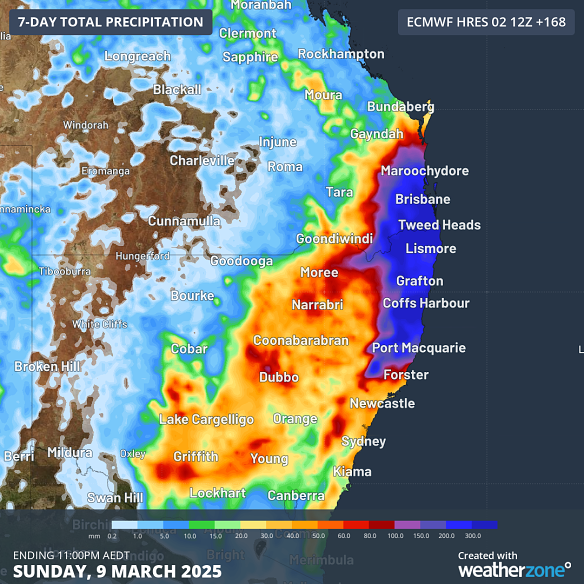
The weather bureau says the heaviest rainfall and the greatest potential for severe flash flooding will be south of where Cyclone Alfred makes landfall.
“The winds around a cyclone travel in a clockwise direction, so the heaviest winds and strongest rainfall occurs on the southern flank of the system,” BOM senior meteorologist Kimba Wong says.
More than 700 millimetres of rain is possible in Brisbane from late Wednesday, putting the south-east corner at risk of severe, potentially deadly flooding.
The heavy rain is likely to intensify on Thursday and Friday and continue into the weekend.
Why is Alfred so low?
Loading
“There are a few contributing factors,” Wong says.
The water temperature in the southern Coral Sea is much warmer than usual – about 26 to 27 degrees – which is helping fuel Cyclone Alfred.
Also, Alfred is largely being steered by an upper trough currently sitting over eastern Australia that is driving it south.
“What’s changing is that the upper trough is being replaced by an upper ridge, in kind of like a wave pattern. It’s that upper ridge that will change the direction of the cyclone and see it head west, towards the Queensland coast,” Wong says.
What has the Queensland government said?
Queensland Premier David Crisafulli told residents on Monday, “Now’s the time to prepare”, including having tinned food, making an emergency kit, gathering passports and clearing debris from properties.
He also urged residents of the bay islands off Brisbane to consider evacuating while it was still an option.
“We are putting all the preparations in place, and we’re asking Queenslanders to do the same. It is important that people take this event seriously,” Crisafulli said.
The Queensland government has asked telecommunications companies to increase network capacity to cope with an expected jump in internet usage and millions of messages throughout the emergency. It has also asked supermarkets to ensure shelves were regularly restocked amid a rush for bottled water and other essential items.
Loading
All Brisbane CityCat and ferry services have been suspended until further notice. Brisbane’s kerbside collections have also been suspended, with residents advised to remove any items from the footpath and secure them.
Sandbagging stations have opened across Brisbane, with hundreds of people queuing for hours at depots on Monday. Residents can also take green waste to the city’s Resource Recovery Centres for free as they prepare their homes.
What has the NSW government said?
The NSW State Emergency Service will deploy additional flood rescue and storm response staff to the Mid-North Coast and Northern Rivers, a region that was devastated by floods in 2022.
“We have also sent communication equipment, support personnel, aviation resources and specialised vehicles ahead of the forecasted impacts later this week,” NSW SES Assistant Commissioner Nicole Hogan.
NSW Emergency Services Minister Jihad Dib assured locals the authorities are doing “everything we can” to prepare for the looming system.
“We’re cognisant of what the Northern Rivers have gone through and some of the trauma that they carry,” he said.
What is a category 2 cyclone?
Category 2 cyclones can generate destructive wind gusts between 125km/h and 164km/h, which can bring down trees and power lines, topple caravans, tear boats from their moorings and damage houses.
Cyclone categories are all based on the wind strength, with 1 being the lowest and 5 being the highest. However, the categories do not take into account the severity of the rain or potential flooding.
“A category 1 cyclone can bring more rain and flooding than a fast-moving category 5 that rips through an area,” Wong says.
The BOM has advised there is a “low risk” of Alfred being upgraded to a category 3 before it crosses the coast, meaning wind gusts of between 165km/h and 224km/h.
How long is Alfred expected to last?
“That’s the million-dollar question. It really will depend on the speed of the system and when it makes landfall and how quickly it moves inland,” Wong says.
Although it may make landfall as early as Thursday night, Alfred may still pose a risk of heavy rainfall and flooding across the weekend.
There is also the potential for delayed flooding to occur early next week as water moves through river catchments.
“Once it moves further inland, it will likely weaken from a tropical cyclone into a tropical low; however, those systems can still bring torrential rain with them,” Wong says.
Start the day with a summary of the day’s most important and interesting stories, analysis and insights. Sign up for our Morning Edition newsletter.
Marissa Calligeros is a journalist at Brisbane Times. She was previously an editor at The Age.Connect via Twitter or email.
Loading
Discover more from World Byte News
Subscribe to get the latest posts sent to your email.
