





Residents in more regions of northern NSW towns have been told to evacuate as Cyclone Alfred makes its way to the east coast. Follow our live coverage.
Residents in more regions of northern NSW towns have been told to evacuate as Cyclone Alfred makes its way to the east coast. Follow our live coverage.
Hello and welcome to our live coverage as Cyclone Alfred approaches the Queensland coast, triggering evacuation orders in northern NSW.
Here is a recap of key developments:
- The Bureau of Meteorology’s latest tracking map shows Alfred is forecast to hit the mainland about 11am (Queensland time) tomorrow.
- The cyclone is expected to lash northern NSW and South East Queensland with heavy rain and wind, forecast to peak late today and early tomorrow.
- The cyclone is set to trigger wind gusts up to 155km/h and 800 millimetres of rain into the weekend from Brisbane to NSW’s Northern Rivers when it eventually arrives.
- Residents in parts of north-east NSW, including in the Northern Rivers, were told to evacuate last night or risk being stranded by floodwaters. Residents in some impacted areas, including North Macksville, Macksville, Bowraville, Nambucca Heads and Gumma, were told to evacuate by 8am today.
- Schools, public transport, major roads and airports are closed, with elective surgeries also put on hold, but emergency departments remain open.
- The tropical cyclone will be the first to directly hit South East Queensland and north-east NSW in more than 50 years.
- Maps show Tropical Cyclone Alfred’s likely path as it heads for the coast. Follow its progress here.
- How extensive the damage will be when Alfred hits is still unclear. Here is everything NSW and Queensland residents need to know as the situation progresses.
NSW Premier Chris Minns has said thousands of people have heeded evacuation warnings as evacuation orders extend from the Gold Coast in Queensland to areas in Tweed on the far north coast and inland in Lismore as Clyone Alfred makes its slow approach to the coast.
Evacuation orders have also been issued for waterfront areas along NSW’s mid-north coast due to predicted flooding. Nearly 30,000 homes are under evacuation order across 18 areas, affecting 19,000 people. A further 24 areas are under watch or prepare to evacuate orders.
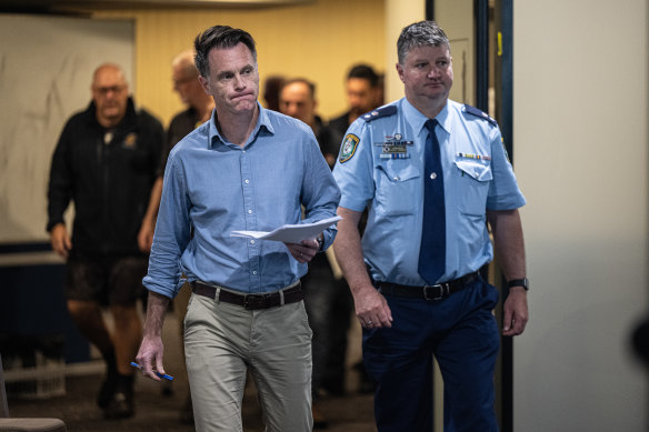
“If you’re one of the few people that are remaining in your house, and you’re in an evacuation area, you’re one of the only people in your street left, and you will literally be by yourself,” Minns said.
“Please follow these evacuation orders unless you have to stay off the roads.”
Local Emergency Operations Controller, NSW Police Superintendent Scott Tanner said conditions will get worse as Cyclone Alfred approaches.
“We don’t need people to get complacent because this weather system seems to have slowed. It is still packing a very mighty punch,” he said.
Residents in Tweed are also being told to conserve water as power outages affect the water pumps.
Fresh drinking water can be collected at evacuation centres. Power has been restored to some homes, with the number of outages decreasing from 43,000 to 36,000 this morning.
Two people have been rescued from a bedroom after a large tree collapsed on a house in Currumbin Valley on the Gold Coast.
Firefighter crews used saws to free the people, who suffered minor injuries.
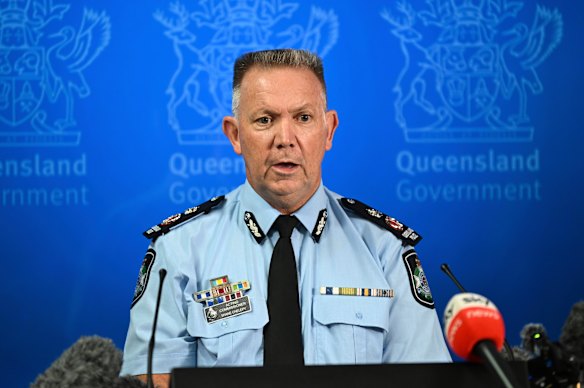
Acting Police Commissioner Shane Chelepy said emergency crews were now starting to see a number of requests for help, particularly on the Gold Coast, as intense wind and rainfall hits the region.
He said there had been 11 search and rescue jobs since yesterday, including for jet ski riders, swimmers and kayakers.
“Now is not the time to be in the surf, and all you’re doing is putting emergency services at risk and yourself at risk,” he said.
Chelepy said emergency crews also had reports of several large trees down, and erosion along the coastline.
“But pleasingly we’ve had no reports of inundation to properties at this stage,” he said.
Queensland Premier David Crisafulli praised the community’s preparations for Cyclone Alfred as “remarkable”.
“The vast majority of people have done the right thing and, my view is, if you give people the information, humans rally in times of crisis and people really, really have,” he said.
The premier also shared a happy piece of news. Crisafulli said twins were born last night in the small township of Dunwich on North Stradbroke Island, as the region was buffeted by cyclonic winds.
“In events like this, there are always little moments of magic and overnight, a set of twins were born on Dunwich, and we had paramedics and midwives who assisted the mum, and they continue to care for her, and that’s one of those little gems in an otherwise really, really stressful time for everybody.”
Tropical Cyclone Alfred will weaken to a category 1 storm before making landfall tomorrow, the weather bureau has announced.
Speaking at a press conference with Queensland Premier David Crisafulli, the bureau’s Brisbane manager Matthew Collopy said Cyclone Alfred would weaken to a category 1 system as it crosses the coast.
“Now, as the cyclone moves across the Moreton Bay islands, it is expected to weaken from a category 2 to a category 1 system. That will mean that destructive winds are unlikely for Brisbane itself,” Collopy said.
“But damaging wind gusts up to 120km/h are expected, and they will develop quickly as the system approaches.”
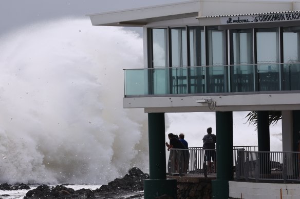
Queensland is usually beautiful one day, perfect the next. But the iconic Gold Coast beaches are being chewed up by the ocean as Cyclone Alfred nears.
An enormous drop has formed outside Jewel Private Residences in Surfers Paradise.
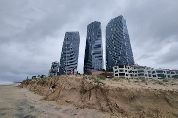
Surf Life Saving Queensland lifesaving services manager Natalie Edwards urged residents to stay away from the beaches.
“We are experiencing erosion along Gold Coast beaches already that has created cliff drops of up to two metres in highly populated areas of Surfers Paradise, Main Beach down to Burleigh and Coolangatta,” Edwards said.
“Now is not the time to head to the beach for a look, especially with young children who may be pulled out by the fast-moving tides that are encroaching on walkways and areas that normally would be far from the water.
“Please don’t put at risk emergency services personnel because you want to venture out in these conditions.”
A number of locations across South East Queensland and northern NSW have already received more than 200 millimetres of rain in one day.
“In the past 24 hours, we’ve certainly seen the rain ramping up,” Bureau of Meteorology meteorologist Miriam Bradbury said in an update on Friday morning.
“A few of these locations, particularly through north-east NSW, have seen over 200mm of rainfall on top of rainfall totals of over 200mm from the day before. That means our two-day rainfall totals are already well over 400mm for some locations.”
Some of the highest 24-hour rainfall totals, to 8am Friday AEST, were:
- Meldrum (NSW) 220mm
- Dorrigo (NSW) 209mm
- Upper Crabbes Creek (NSW) 185mm
- Lower Springbrook (Qld) 147mm
- Palm Beach (Qld) 139mm
Bradbury said Cyclone Alfred’s position is not changing much from one track map to the next, given its slow pace.
The wind and rain is expected to increase throughout Friday afternoon ahead of tomorrow’s coastal crossing.
The bureau advises heavy to locally intense rainfall, which may lead to dangerous and life-threatening flash flooding, is likely to develop from this afternoon
NSW Premier Chris Minns is providing an update on Tropical Cyclone Alfred from Lismore in the Northern Rivers about 12.30pm (AEDT).
He is being joined by Emergency Services Minister Jihad Dib, Lismore MP Janelle Saffin, Senator Tony Sheldon and senior representatives from the NSW SES and NSW Police.
Watch the press conference live below.
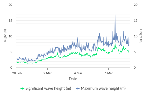
A freak wave measuring a massive 16.88 metres high has been recorded by a buoy near Brisbane.
The mammoth swell, recorded at 10am yesterday, beat the previous maximum wave height of nine metres, also recorded yesterday.
On Wednesday, a 12.3-metre wave was recorded along the Gold Coast. The buoy has since sustained significant damage due to Tropical Cyclone Alfred’s impact, and data is no longer being recorded.
Credit: Queensland Government
Queensland Premier David Crisafulli has provided an update on Tropical Cyclone Alfred.
Watch the full press conference below.
The NSW SES has responded to 1100 incidents in the past 24 hours, including flood rescues as low-lying areas become “inundated” with water, Commissioner Mike Wassing said.
The SES has already made three rescues for people trapped in floodwater this morning, with more rescues under way.

“We’re already getting flood rescue calls this early into the incident, and this situation will deteriorate in the next 24 to 48 hours … I can’t be clearer, that do not drive through floodwaters,” Wassing said.
“Whilst some of the overnight conditions may not have been as bad as people may have expected … now is not the time to be complacent.”
There are currently 23 areas under evacuation warnings, with flash flooding closing off evacuation routes in low-lying areas.
Bureau of Meteorology senior meteorologist Jane Golding said regions already battered by rain will receive a deluge overnight as the cyclone inches closer to the coast at a speed of 6km/h.
“We will see an escalation or a deterioration overnight, as Cylone Alfred moves close,” Golding said.
Winds of more 155km/h are expected north of Cape Byron, while waves up to nine metres high have been recorded along the coast.
“Those large, powerful waves mean very dangerous conditions along the coast and beaches,” Golding said.
North Coast Minister Rose Jackson said two extra evacuation centres had been opened, with 17 centres in total in northern NSW.
More than 165 people have registered at those centres, with another 170 people staying in hotel and motel accommodation.
“I want to reassure people that if you need somewhere to stay, the evacuation centres are open, and they are there to welcome you during this event,” Jackson said.
“It is incredibly important that people listen to the advice of emergency services. Know where to access that information and check it regularly. This is not the time to go for a swim or a surf. This is not the time to go for an unnecessary drive.”
Residents on the NSW coast as far south as Port Macquarie are now subject to emergency warnings, evacuation orders and flood risks.
Residents in low-lying and waterfront areas, including Hasting River Drive, Hibbard Drive, Settlement Point and North Shore in Port Macquarie were told to evacuate before 1am today.
A flood watch-and-act alert has also been issued further south in Laurieton, North Haven, Dunbogan and Kew, while residents as far south as Taree have also been issued a flood advice warning, with minor to moderate flooding on the Gloucester and Manning Rivers expected.
Discover more from World Byte News
Subscribe to get the latest posts sent to your email.
