

Residents in Port Hedland and surrounding areas have been ordered to stay indoors and shelter as winds pick up, with the centre expected to cross the coast this afternoon.
Residents in Port Hedland and surrounding areas have been ordered to stay indoors and shelter as winds pick up, with the centre expected to cross the coast this afternoon.
People have been asked to desist from walking and driving around Port Hedland as a cyclone bears down upon them.
The Hedland State Emergency Service wrote online this morning a blunt warning after seeing people driving and walking around town.
“Do not drive on emergency warning. The shops are closed, the service stations are closed … don’t do it. With the cyclone just hours away you risk your life doing these things. Don’t do it to your family.”
Multiple other residents whiling away their emergency lockdown on Facebook have reported and posted videos of people walking past their homes.
“So many idiots driving around in Port,” wrote one. “Go home.”
“Seriously, stop driving around ya bloody knobheads!” said another.
Some have blamed the new system – in which as of last July, Western Australia has adopted the Australian Warning System for bushfire, cyclone, flood and storm warnings.
This means instead of emergency services using the old Blue Alert, Yellow Alert, Red Alert and All Clear warning system for cyclones, they use the same three warning levels as for bushfires: Advice, Watch and Act and Emergency Warning, with their corresponding colours of yellow, orange and red.
“Everyone knew on a Red Alert … you were confined to your home and not allowed to leave until the all clear, when the police would again go around town with their sirens going again,” one commenter wrote.
“Unlike new system where nobody knows what’s going on.“We reckon if you can’t work out that warning system you might just be a “bloody knobhead.”
A media conference with Fire and Emergency Services Commissioner Darren Klemm and the Bureau of Meteorology’s General Manager Environmental Prediction Services Matthew Collopy is set to begin at 12.30pm WST.
Despite its regular population of 16,000 there are currently only 124 people sheltered in the Port Hedland evacuation centre at the JD Hardie Youth and Community Hub, according to Premier Roger Cook.
Speaking from Geraldton in WA’s Mid West Cook said there was a further 43 people at the evacuation centre in Karratha, which will now be spared the full brunt of TC Zelia after she began tracking east.
Cook said Zelia was “really dangerous and big and it’s one which is going to threaten the communities right across the Pilbara in particular.”

“Our hearts go out to the people in Port Hedland today, they’ve been in lockdown since 6.30 last night, under emergency cyclone warning rating,” he said.
“This is a serious storm, and it’s one which is going to have a significant impact on the communities throughout the Pilbara.”
Cook said emergency response teams were stationed 720 kilometres south west in Carnarvon and they were ready to fly in to Port Hedland after Zelia passes through.
He said he had already had conversations with Prime Minister Anthony Albanese about deploying the defence force.
“We particularly rely on the ADF for heavy haulage, heavy lift equipment to make sure that we can get that into Port Hedland and other towns as needed. So those conversations have already taken place,” he said.
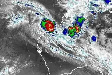
To the latest update from the Bureau of Meteorology now, with a warning that Severe Tropical Cyclone Zelia is about to make landfall near DeGrey River mouth east of Port Hedland.
Port Hedland looks likely to avoid the very destructive core of the cyclone, BOM says.
BOM has upgraded the wind gusts expected at the core of Tropical Cyclone Zelia and narrowed the central area of impact, with the cyclone set to make land fall just east of Port Hedland.
The forecast has been shifting back and forth as the cyclone moves off the coast, but the current analysis has Zelia continuing to move south and make landfall at 4pm AWST.
The bureau is confident the cyclone is now most likely to the east of Port Hedland, with wind gusts at its core having since been upgraded to 290km/h.
BOM said the area east of Port Hedland would bear the brunt of the cyclone, but said the broader area of impact was expected to span 400 kilometres along the coast between Wallal Downs and Roebourne and experience wind gusts between 120-160km/h.
The most intense impacts are expected to be felt at the time of crossing, with bands of showers and thunderstorms wrapping around the cyclone and bringing destructive winds, rain and flooding and storm tides and inundation.
BOM warned wind gusts at the core of the cyclone were likely to lead to the destruction of trees and permanent structures.
The system is likely to move south through the Pilbara and into the Gascoyne over the coming days, continuing to lose intensity as it reaches Tom Price but bringing significant rain.
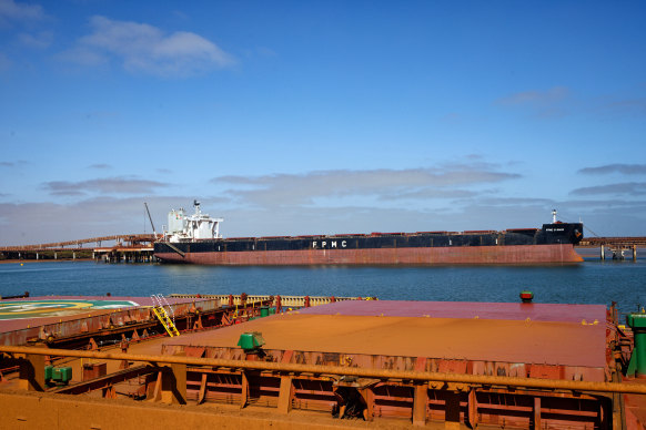
Port facilities, mines and infrastructure in the Pilbara region are in the firing line.
Severe Tropical Cyclone Zelia is forecast to make landfall east of Port Hedland, the nation’s biggest iron ore export harbor, which was shuttered earlier this week along with other regional ports as the Category 5 storm approached.
Very destructive wind gusts up to 290 kilometers an hour are likely close to the center of the cyclone as it crosses the coast. While that’s slightly lower than the 320 kilometers an hour previously forecast, winds will still be strong enough to flatten houses and power lines, and snap trees.
While the Pilbara region is a sparsely populated area, the coastal town of Port Hedland has around 16,000 residents.
After crossing the coast with a “very destructive inner core”, intense rainfall and potential flooding, Zelia is forecast by the bureau to track toward the heart of the Pilbara, which is the center of iron ore operations for some of the world’s biggest miners, including BHP Group and Rio Tinto Group.
Fortescue Ltd. has shut its Iron Bridge mine 145 kilometers south of Port Hedland, according to a spokesperson. The operation produces a high-grade, wet concentrate product that’s sent via pipeline to the harbor for export.
The steelmaking material is a massive revenue earner for Australia.
Should Zelia hold its forecast track and scale, it will be the first Category 5 cyclone to cross the WA coast near Port Hedland since George in 2007, according to the bureau. If Zelia’s wind gusts are maintained, it will be even stronger than George and Cyclone Joan in 1975.
While export ports have been lashed by heavy rain this year from a series of storms, this is the first cyclone of the season that will make landfall and threaten mining operations and their rail links to ports. Storms can flood the massive open-cut iron ore mines, delaying shipments.
Cyclone Sean last month damaged a port facility owned by Rio. The company warned that iron ore shipments would be affected in the first quarter, but kept its overall guidance for 2025 unchanged.
Along with Port Hedland, other ports shuttered are Dampier — which exports iron ore and liquefied natural gas — and Varanus Island, which is used as an energy processing hub. LNG export terminals are located throughout the region, mainly operated by Woodside Energy Group Ltd. and Chevron Corp.
BHP, Rio and Woodside said Thursday they were putting their cyclone preparations in place, which includes suspending non-essential travel to the region, while Chevron said it was monitoring the situation.
Bloomberg
Back to the Bureau of Meteorology, which has just released updated advice.
Winds near the centre of TC Zelia are now more than 200km/h, with gusts recorded up to 285km/h.
She is still moving slowly, at just 8km/h southeast towards the coast.
The cyclone is expected to hit near, or to the east, of Port Hedland and will then take a general southerly track overland and gradually weaken.
Intense rainfall is expected near and to the east of the centre of the cyclone as it crosses the coast.
While there is still a storm tide warning in place, the latest observations decrease the risk of the storm tide for noon today at Port Hedland.
Tides are still likely to rise significantly above the normal high tide mark with damaging waves and dangerous flooding of some low-lying areas close to the shoreline.
Streets are flooded as rain continues to fall in the emergency zone, with residents sharing videos and photos from the scene.
Pardoo, which is up the coast from Port Hedland, has recorded 228mm of rain in the past 24 hours.
Wind gusts in Port Hedland are reaching about 80km/h.
Experts from across Australia are watching closely as Severe Tropical Cyclone Zelia approaches the Pilbara coast.
Professor Steve Turton – an adjunct professor of environmental geography at the Central Queensland University – said he was “particularly worried” about Port Hedland.
“Even buildings and infrastructure built to the highest cyclone rating standards will receive some structural damage from the predicted extreme winds in the core of the cyclone,” he said.
“It’s at the top of the category 5 scale.
“The record-breaking sea surface temperatures offshore (over 31 degrees) are feeding this monster, along with exceptionally favourable atmospheric conditions.”
Turton said the system’s slow forward motion would make for prolonged extreme winds and intense rainfall around the core as it crossed the coast.
“It’s too early to draw a direct link between global heating and this particular cyclone, but its rapid rate of intensification and the exceptionally warm ocean heat content suggest aspects of this extreme weather event may be attributed to anthropogenic climate change,” he said.
“Great Hurricane Milton in the Gulf of Mexico last October is the most recent global example of such an intense system. Luckily it weakened considerably before hitting central western Florida.”
Nine News Perth reporter Sarah Smith is in Port Hedland, reporting as the Category 5 storm approaches.
“Everyone in Port Hedland is in lockdown, there is nobody on the streets,” she said from the safety of the Hedland Hotel.
“It’s very windy, very rainy and it’s a nervous wait for locals with the cyclone due to hit a lot earlier than had been predicted.”
TC Zelia is now expected this afternoon, rather than evening.
Smith said people had flocked to the shops in town to stock up on water and food yesterday as they prepared as much as they could.
Many had been hard at work sandbagging homes and businesses.
“It’s a ghost town, and now everybody is indoors bracing for what’s to come,” she said.
“It’s completely grey skies and palm trees blowing in the wind.”
Discover more from World Byte News
Subscribe to get the latest posts sent to your email.