





Almost 100 warnings are in place across northern NSW as Cyclone Alfred approaches, with towns as far south as Port Macquarie told to evacuate.
Almost 100 warnings are in place across northern NSW as Cyclone Alfred approaches, with towns as far south as Port Macquarie told to evacuate.
By Riley Walter and Amber Schultz
Updated March 7, 2025 — 11.29amfirst published at 5.21am
Residents in parts of NSW’s Northern Rivers region have been ordered to evacuate and thousands remain without power as the slow-moving and destructive Tropical Cyclone Alfred edges closer to land.
Those in Alfred’s firing line were told to leave by 9pm on Thursday or risk not being able to evacuate when the storm made its forecast landfall on the South East Queensland coast late on Saturday morning.
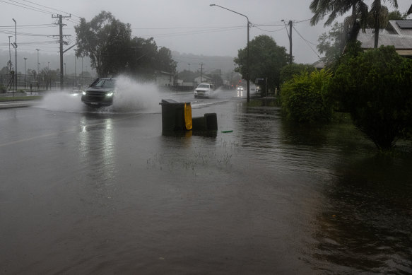
“You must evacuate before this time because forecasted heavy rainfall will close evacuation routes,” the SES said.
Almost 100 warnings are in place across north-east NSW, with evacuation orders extending as far south as Port Macquarie.
The still reeling Northern Rivers town of Lismore, which was devastated by record flooding in 2022, has been warned its CBD is at risk of flooding again. The town has received more than 150 millimetres of rain in the past 24 hours as residents hunkered down. Other areas subject to evacuation orders include Kyogle, Tumbulgum and Fingal Head.
Loading
The Bureau of Meteorology’s latest update, current from 11am Friday (NSW time), forecast Alfred to cross the coast between Noosa and Coolangatta, near Moreton Island, on Saturday morning.
The weather bureau’s most recent track map shows the storm hitting the mainland north of Brisbane as a category 1 at about 11am on Saturday. Alfred will remain over Brisbane for several hours, the track map shows.
Alfred’s forecast path has changed significantly since Australia’s east coast was put on notice last weekend, after initially being expected to make landfall late on Thursday or early Friday.
Advertisement
The category 2 storm, which could now reach the coast as a category 1, is still expected to maintain its intensity despite the possibility of it being downgraded.
Sustained winds near the storm’s centre were holding steady at 95km/h on Friday morning, the weather bureau said, while wind gusts up to 130km/h had been recorded. Residents in north-east NSW have been warned that they could face winds exceeding 100km/h.
More than 36,000 homes were without power on Friday afternoon. Power may not return for several days, with conditions too dangerous for crews to go out in and conduct repairs.
More than 300 NSW schools, along with TAFEs and childcare centres, have been closed until at least Monday but could be shut longer if Alfred makes landfall later than expected.
With Alfred’s delayed arrival came warnings from authorities that severe weather conditions, including damaging gale force winds of more than 100km/h and hundreds of millimetres of rainfall daily, would be prolonged the slower the first tropical cyclone to hit NSW since 1990 made its way towards land.
On early Friday morning, Alfred was about 165 kilometres east of Brisbane and 140 kilometres east to north-east of the Gold Coast. It’s moving at a speed of 6km/h, a marked decrease from earlier in the week when it was tracking towards the coast at 11km/h.
A monster 17-metre wave was recorded near Brisbane at the Moreton Bay monitoring site on Friday morning, as the coast was battered with monstrous swells.
Weather conditions are expected to worsen across Friday as winds pick up and heavy rain sets in. Hundreds of millimetres of rain could fall daily, with some parts of north-east NSW forecast to be drenched with up to 800 millimetres of rain over several days. The weather bureau has warned widespread heavy rainfall could lead to life-threatening flash flooding.
NSW Deputy Premier Prue Carr on Friday said the cyclone’s changing forecast had led to heightened tensions.
Loading
“There is a significant amount of anxiety in the community as we wait for this,” she said.
SES Commissioner Mike Wassing said frontline crews have responded to 1100 incidents in the past 24 hours, including at least three flood rescues as low-lying areas become “inundated” with water.
“We’re already getting flood rescue calls this early into the incident, and this situation will deteriorate in the next 24 to 48 hours … I can’t be clearer … do not drive through flood waters,” he said.
“Whilst some of the overnight conditions may not have been as bad as people may have expected … now is not the time to be complacent.”
There are currently 23 areas under evacuation warnings, with flash flooding closing off evacuation routes in low-lying areas.
Bureau of Meteorology senior meteorologist Jane Golding said regions already battered by rain will receive a deluge tonight.
“We will see an escalation or a deterioration overnight, as Cylone Alfred moves close,” she said.
Loading
Winds greater than 155km/h are expected north of Cape Byron, while waves up to nine metres high have been recorded.
“Those large, powerful waves mean very dangerous conditions along the coast and beaches,” she said.
The Bureau of Meteorology will now provide updates hourly instead of every three hours.
Start the day with a summary of the day’s most important and interesting stories, analysis and insights. Sign up for our Morning Edition newsletter.
Riley Walter is a breaking news reporter at The Sydney Morning Herald.Connect via Twitter or email.
Amber Schultz is a crime and justice reporter with The Sydney Morning Herald.Connect via Twitter or email.
Loading
Discover more from World Byte News
Subscribe to get the latest posts sent to your email.
